Ground Truthing: Notes on an Essay by Paul Carter
Paul Carter, Ground Truthing: Explorations in a Creative Region (Crowley: University of Western Australia, 2010)
“Uncanniness does not first arise as a consequence of humankind; rather, humankind emerges from uncanniness and remains within it—looms out of it and stirs within it.” – Martin Heidegger, Hölderlin’s Hymn “The Ister”
Paul Carter’s book is a series of perspectival essays—probes, attempts, rehearsals, prospects—about a region of southern Australia called the Mallee: north of Melbourne and east of Adelaide, spanning the boundary between New South Wales and Victoria, with the Murray River running through it. I have never myself been in the actual place (a notion that Carter’s work, as an artist and historian, seeks to problematize and remake); but having followed Carter’s book through its self-enfolding and-unfolding itinerary, I have experienced an extended journey through the Mallee’s intricate physical and imaginary geographies, across its natural and human histories, into its tracked surfaces and the shifting sedimentations of its ambiguous toponymics.
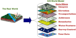
“Ground truth,” and hence the gerundized title “Ground Truthing,” refers ironically to its standard use in spatial studies, as a term of art in remote sensing.
The Esri GIS dictionary defines it thus: “The accuracy of remotely sensed or mathematically calculated data based on data actually measured in the field.” The Wikipedia entry on “ground truth” expounds (under a subheading of “Meterology”) in greater detail:
In remote sensing, “ground truth” refers to information collected on location. Ground truth allows image data to be related to real features and materials on the ground. The collection of ground-truth data enables calibration of remote-sensing data, and aids in the interpretation and analysis of what is being sensed. Examples include cartography, meteorology, analysis of aerial photographs, satellite imagery and other techniques in which data are gathered at a distance.
More specifically, ground truth may refer to a process in which a pixel on a satellite image is compared to what is there in reality (at the present time) in order to verify the contents of the pixel on the image. In the case of a classified image, it allows supervised classification to help determine the accuracy of the classification performed by the remote sensing software and therefore minimize errors in the classification such as errors of commission and errors of omission.
Ground truth is usually done on site, performing surface observations and measurements of various properties of the features of the ground resolution cells that are being studied on the remotely sensed digital image. It also involves taking geographic coordinates of the ground resolution cell with GPS technology and comparing those with the coordinates of the pixel being studied provided by the remote sensing software to understand and analyze the location errors and how it may affect a particular study.
Carter’s book acknowledges this technological horizon as the inescapable starting point of his own meditations:
Ground Truthing, the operation of authenticating aerial photographs by checking (and identifying) the pixelated images through walking the ground, is not simply a utilitarian activity essential to the operations of clear-felling or cluster-bombing. It implicates us all, for it describes the conceptual place from where all the world’s surface is increasingly being seen. It is not possible—nor has it been for fifty years—to look up into the night sky without seeing military hardware hurrying purposefully down their different courses. Their single eyes, at once awe-inspiring and discomforting, are our own.
Yet his exploration of the Mallee and the uncanny “grounding” of its truth calls in question how at home we have become with a number of interrelated terms taken for granted in a mentality shaped by an ever-expanding technological practice—taken as long “settled” in their definition, however great the technical challenges might be in realizing them “on the ground” or “in the field”: terms such as “measure,” “data,” “features,” “content,” “sense,” “classification,” “observation,” “property,” “surface,” “understand,” “error,” and “truth.” Carter thus challenges the assumed order of priority between the conceptual / digital technology of the spatial image and what Mallee may give of itself (as figural “gift” more than mathematical “datum,” information) to those who have sought to stand, emplaced, on its sandy ground.
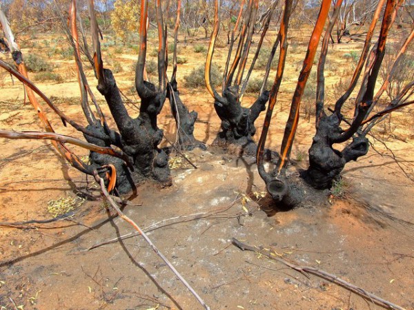
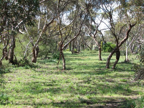
The ground-truth of the Mallee is, on the one hand, as Carter allows us to glimpse in chapter after chapter (which are terse like extended aphorisms), a rich image-space in its own right, whose confirmation can only be sought in an ever-richer appreciation of how those complex images—a perplexing web of landscape features, place-names, narratives, boundary-lines, trails—embed themselves and interleave in physical, narrative, historical, and linguistic “grounds.” He considers the aboriginal stories that constituted in words, gestures, graphic signs, and movements the first topography of the region, and how those stories were iteratively overmarked by colonial encounters and revised in ongoing adaptation to the settlers’ only partially successful attempts to unwind and straighten, into measurable units of property, their spiraling webs of placemaking. The poetic testimony of the itinerant laborer-poet John Shaw Neilson and contemporary artists and writers such as Philip Hunter, John Wolseley, and Carter himself further compound the rich symbolic dynamics of undoings and redoings that compose Carter’s depiction of the Mallee.
As he writes, in reference to Hunter’s paintings, but in a passage that is implicit in the style and treatment of his book as a whole:
Memory is not stratified; its topology is like a marble cake where streaks from the most ancient deposits swirl up and expose themselves in the pavement of the most recent thought; its constitution is like the earth’s—internally revolving, eddying, rising up and falling back. The ground plane is only a cut through this dynamic activity and its thickening to include the hollow between heaven and earth—roughly corresponding to the zone of the atmosphere—enables the poet-scientist to use meteorology metaphorically to describe hidden creative forces at work below as well as above.
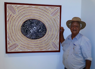
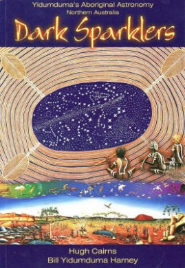 Accordingly, Carter also suggests, in his treatment of the 19th-century account of aboriginal astronomy by settler-ethnographer William Edward Stanbridge and of the contemporary Wardaman Elder Bill Yidumduma Harney’s star knowledge (see his 2003 book Dark Sparklers, with Hugh Cairns) how the solar-aerial technology of modern spatial science may find its organizational and supervisory authority challenged by the inventive repertoires of ground-based indigenous cosmologies.
For these, in the crystalline reflections of a salt lake or from the incised surfaces of the Lake Tyrrell Bark Etching (one of which was exhibited in the Parisian Universal Exhibition of 1855), the stars look not only down, but also up and around:
Space between sky and earth is not a third entity: it is tirille, sky and earth considered as a composite movement form, an ‘up-and-down’, a quivering spider’s web. An application of the mythic thinking that avoids reifying it has to keep the movement alive. Instead of thinking in terms of fixed relations and fixed passages, it appreciates the shimmer of the net as young men and women dance, the sparkle of the stars as people are talking. The region invoked by the spider’s web is not a geographical unit but a social choreography, scored with ceremonial paths and meeting places. Vertical and horizontal axes of communication become reconciled—what ‘links the air to you, up to the star’ also ‘guide[s] you direct to it straight across country.’
The final chapter of Carter’s book sets out his vision of an alternative modernity, recomposed of regions where places are made and unmade, the global as a complex, singular region composed of regions at each scale. The Mallee, a special region, a place of places, thus becomes for Carter exemplary in its very singularity, which by resisting the scanning and measuring gaze, spurs the imagination to reimagine other densely recalcitrant regions, “the other places,” as Carter writes, “from which all places come.”
“It may be one of the most important things we can do,” he concludes—
to keep alive the memory of places in other places—not to allow the Mallee to pass out of mind as it slips beyond the horizon. When the streaking calls of its parrots, the desolate bleating of flocks, the abundance of ruins and the roseate light coming through the cobwebbed morning mallee tree is forgotten, a scale of being is sacrificed, and the land becomes a plaything of planners, agribusiness and unimaginative governments. . . . I would like to lay the Mallee through Long Island, let it stretch from the Appalachians in a long crescent to the uppermost reaches of the upper Hudson, and say to the gallery-goers—for how else ccould this be visualized except through some digital deceit—this is the future. It is coming. . . . It would be as if we inverted the backward focus of Robert Smithson’s art, and probed instead the geomorphological face of the future. The future is not entropic, a spreading ring of ruin. Knowing about climate change, we know it looks like the Mallee did 100,000 years ago.
Originally posted on Cross Pollen Blog >